The Tracy Arm Megatsunami: A Comprehensive Guide to Landslide-Generated Tsunamis
Overview
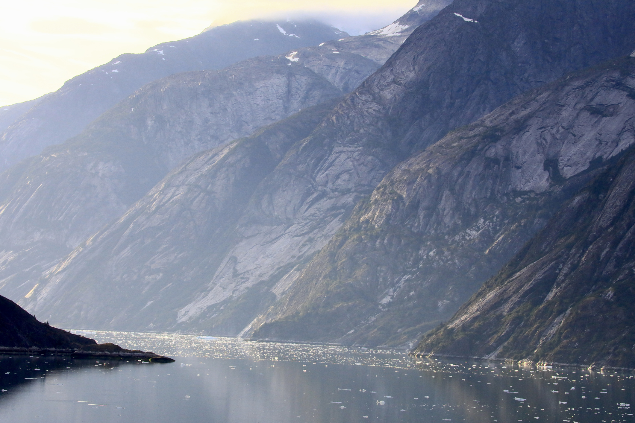
On August 10, 2025, at 5:26 AM local time, a colossal landslide struck Alaska's Tracy Arm fjord, unleashing a tsunami that reached heights of 481 meters—the second tallest ever recorded on Earth. A wedge of rock measuring at least 63.5 million cubic meters detached from a mountain above the fjord, crashing into the waters at the terminus of the South Sawyer Glacier. The impact generated a breaking wave initially 100 meters high, racing across the fjord at speeds exceeding 70 meters per second. When it slammed into the opposite shoreline, the wave surged up steep rocks to a staggering height of 481 meters above sea level.
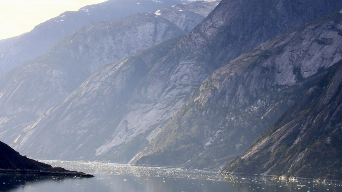
This event, reconstructed in a 2025 Science study by University of Calgary researcher Aram Fathian and colleagues, is a textbook example of a landslide megatsunami. Unlike earthquake-driven tsunamis that rarely exceed tens of meters, landslide tsunamis are far more violent and localized. Since 1925, scientists have documented 27 such events with runups over 50 meters. The highest remains the 1958 Lituya Bay tsunami (530 meters). Remarkably, the Tracy Arm event caused no injuries or fatalities—mostly because it struck early morning in a remote area. But as tourism in Alaska's fjords grows, the next megatsunami may not be so forgiving.
This guide will walk you through the science behind landslide megatsunamis, how they form, how they are studied, and why understanding them is critical for public safety. You'll learn step-by-step how to analyze such events, avoid common pitfalls, and appreciate the tremendous forces at play.
Prerequisites
Before diving into this guide, you should have a basic grasp of:
- Geology 101: Familiarity with rock types, slope stability, and glacial processes.
- Tsunami physics: Understanding that tsunamis are not single waves but a series of waves caused by displacement of water.
- Mathematics: Comfortable with units like cubic meters, meters per second, and heights (runup).
- Map reading: Ability to interpret topographic and bathymetric maps of fjords.
No advanced degree is required—just curiosity and a willingness to learn about one of nature's most dramatic phenomena.
Step-by-Step Instructions: Understanding the Tracy Arm Megatsunami
Step 1: Recognize the Trigger Mechanism
Landslide megatsunamis begin with mass movement. In Tracy Arm, the trigger was a massive rock wedge that had been destabilized by glacial retreat. As the South Sawyer Glacier thinned, the supporting ice disappeared, leaving a steep rock face unsupported. Over centuries, freeze-thaw cycles and seismic activity weakened the rock until it gave way.
- Key fact: The falling rock volume was at least 63.5 million cubic meters—equivalent to over 25,000 Olympic swimming pools.
- Mechanism: The rock fell from a height of roughly 1,000 meters above the fjord, gaining enormous kinetic energy before striking the water.
Step 2: Measure the Initial Wave Height and Speed
Upon impact, the rock displaced water violently, creating an initial breaking wave of 100 meters. This wave traveled across the 1.5 km wide fjord at speeds exceeding 70 m/s (about 250 km/h). To calculate these values, scientists rely on:
- Seismic records: The landslide registered as a moderate earthquake on nearby seismometers, allowing timing of the event.
- Satellite imagery: Before-and-after images reveal the scar on the mountain and the displaced water.
- Numerical models: Computer simulations (like the ones used in the Science study) reproduce wave propagation to match observed runup heights.
Step 3: Calculate the Runup Height
The runup is the maximum vertical height a tsunami wave reaches above sea level. For Tracy Arm, that was 481 meters. This is measured by field surveys of trimlines—lines of stripped vegetation or debris on hillsides. The 1958 Lituya Bay tsunami reached 530 meters, but Tracy Arm is now the second highest on record.
How to measure runup:
- Identify a clear trimline on the slope opposite the landslide.
- Use GPS or laser rangefinders to map the elevation of the trimline relative to sea level (correct for tide).
- Cross-reference with eyewitness accounts (none existed for Tracy Arm, but the trimline was unmistakable).
Step 4: Understand the Localized Nature
Unlike earthquake tsunamis that travel across ocean basins, landslide tsunamis are confined to the body of water where the landslide occurs. The wave energy is concentrated in a narrow fjord, leading to extreme heights locally but minimal impact outside. This is why no one was hurt at Tracy Arm—the nearest town is dozens of kilometers away. However, tourist vessels often cruise these fjords during summer months.
Step 5: Assess the Risk and Mitigation Strategies
Scientists have documented 27 landslide tsunamis with runups >50 m since 1925. Climate change accelerates glacial retreat, increasing the frequency of these events. To mitigate risk:
- Monitor unstable slopes: Use satellite InSAR (Interferometric Synthetic Aperture Radar) to detect ground movement.
- Establish early warning systems: Seismic networks and water-level gauges can provide minutes of warning in fjords.
- Regulate tourism: Avoid anchoring or cruising near unstable rock faces during early morning hours (when landslides are more likely due to thermal stress).
Common Mistakes
When analyzing or discussing landslide megatsunamis, avoid these pitfalls:
- Confusing runup with wave height: Runup is the vertical surge on land; the wave height in open water is much smaller. Tracy Arm's initial wave was 100 m high, not 481 m.
- Assuming earthquake tsunamis are always the biggest: Landslide tsunamis can be orders of magnitude taller locally. The 2004 Indian Ocean tsunami had runups up to 30 m; Lituya Bay was 530 m.
- Ignoring glacial retreat: Many think landslides are random, but they often occur in recently deglaciated valleys. Climate change makes these events more likely.
- Overlooking the “near-miss” factor: Just because Tracy Arm had no casualties doesn't mean future events will be harmless. Timing and location matter—a similar event in a busy fjord during summer could be catastrophic.
Summary
The Tracy Arm megatsunami of August 2025 stands as a stark reminder of the power of landslide-generated tsunamis. With a runup of 481 meters, it is the second highest ever recorded. The event was triggered by glacial retreat, a process accelerating worldwide. Understanding the physics—from trigger to runup—is essential for hazard assessment. By monitoring slopes, modeling waves, and respecting the unpredictable nature of these events, we can better protect lives and infrastructure. This guide has covered the key steps to analyze such a phenomenon, common mistakes to avoid, and the broader context of climate-driven risks.
For further reading, refer to the full Science article by Fathian et al. (2025) and explore real-time landslide monitoring tools available from geological surveys.